Australian households at risk of $25 billion damage bill from climate-related hazards By Charis Chang
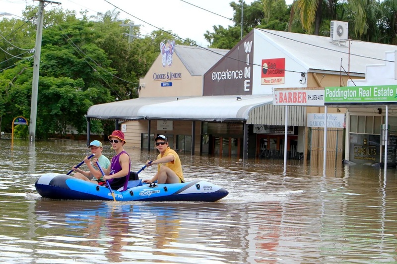
Hundreds of thousands of Australian households are forecast to face huge yearly damage bills thanks to climate change related hazards in the next 30 years — with some major cities among the worst affected.
Analysis provided exclusively to news.com.au from Climate Valuation, shows the worst-hit communities in each state and estimates the number of residential properties categorised as being of “moderate” or “high” risk are expected to increase by 54 per cent within the next 30 years, and more than double within 80 years.
The number of high risk properties rises from around 491,000 this year, to 646,000 in 2050, and 713,000 in 2060 and 1.1 million by 2100.
Data shows the local government areas of Brisbane and Gold Coast top the list for the value of properties at risk, followed by Melbourne, and then another two Queensland sites: the Sunshine Coast and Moreton Bay.
By 2100 the yearly damage bill is estimated to be a total of $25 billion across the country.
The forecast has serious implications for homeowners as high risk properties may not be insurable or it may come at a very high cost unless adaptation measures are completed, while moderate risk properties may face higher insurance costs.
“Unfortunately a lot of families will be put in harm’s way and will pay through higher insurance costs as floods and bushfires worsen,” Climate Valuation chief executive officer Dr Karl Mallon told news.com.au.
He said active property market buyers needed to carefully consider the cost of higher insurance premiums over the lifetime of their mortgage. Some hazards like coastal inundation flooding and subsidence are also not generally covered by insurance policies.
“We are coming across many cases of homeowners who have been faced with unaffordable or unavailable insurance,” he said.
“This is a very dangerous situation because it exposes families to financial ruin if their home is damaged during an extreme weather event.”
News.com.au has previously reported on weaknesses in the planning system that mean homeowners are not being alerted to climate change hazards, which have the potential to impact their homes by the time they’ve finished paying off their mortgages.
The Climate Valuation analysis assesses 14 million properties across the country, looking at the risk from five different hazards that are expected to worsen due to climate change: forest fire, coastal inundation, soil subsidence (not including coastal erosion), extreme wind including cyclones and flooding (riverine and surface water).
Across Australia, damage costs have been estimated to rise by a staggering 257 per cent, from an average of $7 billion in 1990, to $25 billion in 2100. The hazards that are expected to contribute most to this increase are flooding, coastal inundation and extreme wind including cyclones.
The figure does not include impacts to public infrastructure, although a recent Deloitte special report found natural disasters arising from climate change could cost Australia $74 billion by 2060.
“Currently in Australia there is no national program to assist vulnerable communities in managing the physical impacts of climate change,” Dr Mallon said.
“Without appropriate support, it feels like people are being left on their own to prepare for the physical risks and financial fall out.”
The analysis estimates 2.6 million properties would be classified as being at moderate or high risk within the next 30 years.
By 2100, about 1.1 million properties are expected to be categorised as high risk, up from 491,000 this year, while 3.1 million properties would be at moderate risk, up from 1.2 million.
Brisbane is facing the largest bills with climate related hazards potentially causing $2 billion worth of damage to residential properties by 2100.
However, the damage could well be more devastating in small communities such as the riverside LGA of Canning, a south eastern suburb of Perth in Western Australia, where around 49,711 properties are facing damages worth around $538 million.
Climate Valuation’s forecast is based on a high-emissions pathway of RCP 8.5, with no action to reduce emissions, although policies are already beginning to move us away from this scenario.
However, Dr Mallon said current global emissions were still aligned with this pathway and so his organisation had to assume the worst in its physical risk modelling.
“It’s hard for many countries to embark on concerted global action to mitigate climate change when wealthy countries like Australia continue to expand coal mines and refuse to commit to net zero emission targets,” he said.
While many homeowners would not expect their properties to be impacted by climate change, there are some unexpected ways they could be affected.
This includes about 10 million properties assessed to be at low risk by 2100, which means they should be able to be insured at a reasonable price.
Low risk hazards include exposure to extreme wind, which buildings are generally constructed to withstand.
Another example is a house built on clay soils that could be impacted by worsening droughts due to climate change, which could possibly suffer damage to its foundations due to soil subsidence.
Climate Valuation provides a free tool on its website for homeowners to check what level risk their properties could be facing in the future.
These are the worst hit communities in each state.
New South Wales
The local government areas of Central Coast, Tweed and Lake Macquarie are expected to face the highest damage costs by 2100.
Costs are expected to increase from $2 billion in 1990, to $6 billion in 2100.
The costs of coastal inundation in particular will increase and become the highest risk, making up 32 per cent of estimated costs.
Flooding and forest fire also make a large contribution to the damage bill.
In 2021, about 140,573 properties within NSW were deemed to be ‘high risk’ from climate change and extreme weather, and this rises to 282,916 by 2100.
Queensland
Coastal inundation is one of the most damaging threats to properties in Queensland.
Back in 1990, the damages due to climate hazards were valued around $2 billion and this was mostly due to flooding, forest fires and extreme wind.
But by 2100 damage associated with coastal inundation in particular, which only contributed 1 per cent of damage costs in 1990, is expected to rise to make up 30 per cent, helping to increase costs to $8 billion.
Damages related to extreme wind, including cyclones, is also expected to grow from 15 per cent to 26 per cent.
The local government areas with the highest damage costs in 2100 are expected to be Brisbane, Gold Coast and Sunshine Coast.
Victoria
Coastal inundation, flooding and the risk of forest fire contribute most to the state’s estimated $4.6 billion damage bill by 2100, rising from $1.5 billion in 1990.
Melbourne, Port Phillip and Kingston are the LGAs with the highest expected damage costs in 2100.
South Australia
The risk from forest fire is expected to double from 9 per cent of the state’s expected damage in 1990, to 18 per cent by 2100.
Costs will rise from $420 million in 1990, to $1 billion in 2100 with flooding, extreme wind and forest fire contributing the most.
Charles Sturt, Port Adelaide Enfield and Adelaide Hills are the LGAs with the highest expected damage costs in 2100.
Tasmania
Launceston, Clarence and Hobart are the LGAs with the highest expected damage costs in 2100.
Flooding, coastal inundation and extreme wind are expected to contribute the most to costs, which are forecast to rise from $90 million in 1990, to $370 million in 2100.
About 5859 properties within the state are deemed to be high risk in 2021, rising to 11,646 by 2100.
Northern Territory
Darwin, Katherine and Alice Springs are the LGAs considered most at risk of the highest damage costs in 2100.
Extreme wind, flooding and coastal inundation are expected to contribute the most to damage bills, which are forecast to rise from $50 million in 1990 to $114 million in 2100.
About 2756 properties within the NT are deemed to be high risk in 2021, rising to 4367 by 2100.
Australian Capital Territory
Damages are expected to rise from $58 million in 1990, to $98 million in 2100, with flooding, extreme wind and soil subsidence contributing the most.
The ACT has no separate local government areas.
About 3054 properties are deemed to be high risk in 2021, and there is a modest increase to 3718 by 2100.